
Investigators are again shifting the search areas for Malaysia Airlines Flight 370, which veered off its flight plan on March 8. Above, an official from the Malaysian Department of Civil Aviation shown in March in Kuala Lumpur, Malaysia. Getty Images
For the third time in less than three months, investigators looking for Malaysia Airlines Flight 370 are poised for a shift in search areas after revising some of their basic assumptions, according to people familiar with the process.
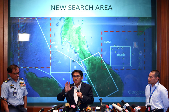
Malaysian officials said Monday they will go to Australia to map out the next phase of the search as costs for the missing jet mount. Azharuddin Abdul Rahman, chief of the Department of Civil Aviation, told reporters the discussions will focus on analysis supporting a new search area.
Without providing any details, he said “it would not be very far away from where the search is going on now.”
Australian authorities previously have said a maximum of 60 million Australian dollars (US$55.5 million) will be set aside for the search. Malaysia has spent 27.6 million ringgit ($8.64 million) on fuel, food and other search-related items.
“That’s not final,” Defense Minister Hishammuddin Hussein said earlier Monday, cautioning that the cost may continue to rise until the plane is found.
Malaysia Deputy Defense Minister Abdul Rahim Bakri said the cost will be equally split between the governments of Australia and Malaysia. China hasn’t announced whether it will contribute, Mr. Rahim said. Two-thirds of the 239 people aboard Flight 370 were from China.
The latest rethinking on the search area, people familiar with the matter said, reflects inescapable uncertainties about the speed, flight path and altitude of the Boeing 777, which mysteriously veered off its flight plan on March 8, flew on for hours and is believed to have run out of fuel before going down in the remote southern Indian Ocean carrying 239 people.
But until the aircraft is found, such assumptions are still educated guesses. Changing the assumed speed, trajectory and altitude, though, can result in sharply divergent underwater search areas, possibly taking teams significantly south or southwest from where they focused their efforts in May.
Another major shift in the search risks stoking public frustration and skepticism about the endeavor, which has been criticized as slow and ineffective.
Some experts who aren’t directly involved in the search said the shift would likely amount to hundreds of miles and create substantial logistics headaches, especially if searchers move farther away from the Australian coast.
No final decisions have been made about where the retooled search will focus and the effort remains “a work in progress,” according to one person familiar with the details. Public disclosure of the new area could come as early as mid-June, this person said, though underwater scanning equipment isn’t slated to begin operating until August.
But last-minute changes in calculations, as well as disagreements among investigators from several countries, still could delay a decision or prompt participants to forgo making immediate changes.
Yet unlike the numerous earlier reassessments in April and May that ended up basically reaffirming search areas, according to people familiar with the process, this time many more options are on the table, including some that would drastically alter certain search parameters. More-rigorous statistical analysis is being used to identify highest-priority areas, these people said, and some of the areas could end up disconnected from each other, unlike previous maps that depicted a single, continuous search zone.
As recently as early May, investigators released a report indicating they believed satellite data showed the plane turned toward the Indian Ocean about two hours into the flight, according to people familiar with the details. But since then, they have concluded that wasn’t the case and the cluster of transmissions was “power cycling” of the jet’s onboard satellite communications system.
If the turn occurred at a different time and location, as investigators now apparently believe—or the jet had more fuel on board at that point than previously surmised—the upshot could be dramatic. It may significantly change assumptions about how fast and far the plane would have been able to fly before its tanks ran dry.
Investigators have been plugging in speeds ranging from a maximum of more than 550 miles an hour to as slow as about 350 miles an hour, according to people familiar with the probe. The goal is to find the best statistical fit and create the most likely scenarios. Slower speeds were used to focus the unsuccessful May search, prompting a new look at faster speeds.
The process highlights the difficulties facing investigators working with scant definitive data. They also confront escalating pressure to reassess the original approach, because so far they have failed to find any traces of Flight 370. Exactly three months after the jet dropped off radar and disappeared, lack of progress has promoted frustration among families of some of the passengers and more broadly around the world.
The backbone of the analysis continues to be a series of communication links, or “digital handshakes,” analyzed by British satellite operator Inmarsat ISAT.LN +1.46% Inmarsat PLC U.K.: London GBp764.00 +11.00 +1.46% June 9, 2014 4:35 pm Volume : 725,851 P/E Ratio 0.52 Market Cap GBp3.37 Billion Dividend Yield 2.88% Rev. per Employee GBp497,724 7707607509a10a11a12p1p2p3p4p 06/05/14 Inmarsat to Launch Pan-Europea… 06/04/14 Malaysia Airlines Flight 370: … 05/28/14 Fresh Support Released That Ma… More quote details and news » PLC. But now U.S., Australian and aviation experts from other countries, in conjunction with Boeing Co., once again are re-evaluating certain assumptions about the plane’s heading, altitude and speed central to determining the most likely search locations.
The U.S. National Transportation Safety Board declined to comment. Malaysian officials, Australia’s search-coordinating agency and the U.S. Federal Aviation Administration didn’t immediately respond. Boeing has said it won’t discuss its role.
Even some participants acknowledge the extent of the challenge. Experts from the various countries are “looking at the same data with their own techniques,” said Mark Dickinson, the head of Inmarsat’s team. “It’s not an X-marks-the-spot thing.”
The new calculations and probability analyses likely will mean “a dramatic widening of the potential search area,” with at least a portion expected to move hundreds of miles farther southwest, according to Tim Farrar, a Northern California satellite analyst who has received updates from investigators. “If that happens, they would have to explain dropping certain areas previously identified as part of any eventual search,” Mr. Farrar said. The effort “is likely to result in a lower probability of success” than experts originally indicated, he added.
Just a month ago, people familiar with the search didn’t expect significant changes in the area to be searched. But since then, as experts revved up analysis of a broader range of possible speeds, some of the same people said leaders of the impending Australian-led contractor search are actively considering replacing some previously designated areas with new ones.
One option, these people said, is to include a patchwork of high-priority sites with some potentially disconnected from other search locations. Last week, the Australian Transport Safety Bureau said the analysis will be refined “in the coming weeks,” but didn’t elaborate
The bureau is seeking bids, due by the end of June, from companies and research organizations to spend nearly a year searching a roughly 400-mile swath of ocean floor some 50 miles wide. But so far, the agency hasn’t identified where that stretch will begin and end, or indicated if certain search areas won’t be contiguous to others.
Satellite data constitutes one of the few pieces of hard evidence, but it alone can’t provide the answers investigators seek. Instead, in a time-consuming process, key assumptions are repeatedly adjusted to see which combination of airspeed, altitude, fuel consumption and other factors best fits the likely path that has the aircraft crossing a number of calculated arcs across the Indian Ocean at precise times stemming from the satellite-plane digital handshakes.
Previous changes in search areas were dramatic. In late March, Australian authorities shifted the search on the surface some 500 miles to the northeast based on updated radar data and new speed calculations. Around that time, Inmarsat released an analysis of satellite communications showing aircraft speeds exceeding 500 miles an hour.
In early May, by which time searchers had shifted focus again and were using a submersible system called the Bluefin-21 to look deep underwater in a limited area, investigators released a report showing the assumed speed of the plane in the roughly 350 miles an hour range.
When acoustic signals, or “pings” thought to come from the plane’s “black box” recorders, turned out be dead ends, investigators stepped up the analysis that is currently under way.
source:wsj.com