
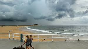
A severe thunderstorm warning has been issued for Sydney, with heavy rain and damaging winds expected to extend from the Hunter region to the Illawarra and inland to Dubbo and Bourke.
The Bureau of Meteorology warned that the thunderstorms were likely to produce flash flooding for several hours.
The storm cell heading for Sydney is near Oberon and is one in a line of thunderstorms in the far west of the state.
“There is a chance it could be severe. Heavy rainfall is the main thing we will see and also possibly damaging wind gusts,” meteorologist Rob Taggart from the Bureau of Meteorology said.
Friday’s storms are forecast to be potentially more severe than those that hit the city late on Thursday afternoon, Weatherzone meteorologist Ben McBurney said.
The worst hit areas on Friday are expected to be in Sydney’s west, where rain arrived as early as 1pm.
See your ad here
Widespread rainfall of between 30 and 40 millimetres are forecast across the Sydney basin, Mr McBurney said.
“Today’s storms will be potentially on the stronger side [compared with Thursday’s].
“We have a bit more moisture around than yesterday, for starters, and also a stronger wind shear. They’re the two ingredients that encourage stronger storms,” Mr McBurney said.
“Yesterday’s storms were fairly strong in some areas but, while there was a lot of rain, most parts of Sydney didn’t see huge amounts of thunder or lightning.
“There was a bit of strong wind around yesterday but nothing clearly damaging. Today we have a heightened risk of those things.”
On Thursday evening, the heaviest falls were in North Parramatta, which recorded 48 millimetres, while temperatures provided another hot, humid and uncomfortable night in the city, dipping only to a low of 22.8 degrees at 2.30am.
But it felt considerably hotter; at 2.30am, it felt more like 25.1 degrees, the Bureau of Meteorology said. The humidity was above 85 per cent all night.
Mr McBurney said a southerly change would move through on Saturday, when a top of 28 degrees was forecast in the city and 30 degrees in the west, while on Sunday a top of 27 degrees was forecast in the city and 28 degrees in the west.
“With that southerly change [on Saturday], we could still see some showers and storms, with the best chance in the morning,” Mr McBurney said.
“Saturday could still be a bit on the damp side in some areas, but as we get into Sunday it should definitely be improving.”
source:theherald.com