UPDATED, 8pm: ONE person was missing presumed drowned, scores were evacuated, hundreds became isolated and nearly one thousand needed help as record January rainfalls and massive seas lashed the Hunter.
As the East Coast Low which dumped a January record of nearly 300mm in less than 24 hours across parts of the Hunter began to move out to sea on Wednesday night, more than 80 Raymond Terrace residents were waiting for the predicted peak of the Hunter River floodwaters before discovering whether their homes were safe.
Emergency crews were needed for at least eight floodwater rescues, however the biggest emergency occurred several kilometres off shore when a middle-aged sailor was washed off a 12-metre yacht near Broughton Island and lost in raging seas.
Two helicopters and several vessels were searching a wide area north of Port Stephens trying to locate the man, who was not believed to be wearing a lifejacket.
The State Emergency Service remained busy with more than 800 calls for assistance across the Hunter as more than 500 residents became isolated at Torryburn and other remote Lower Hunter communities.
The rainfall to 9am on Wednesday was the highest for a January day in the Hunter on record, swelling rivers and keeping swift water rescue teams busy as they helped evacuate hundreds of people to dry land.
But the storm could have been worse, with small high tides and the failure of predicted gale-force winds to eventuate helping reduce the carnage.
“We have dodged a bullet in the sense that if this had happened on the weekend, when the really high tides were coming, places like Raymond Terrace would not have fared so well,’’ SES spokesman Phil Campbell said.
Despite the widespread forecast that major flooding would occur in parts of the region, only a handful of low-lying residences were inundated with floodwaters.
The forecast was for improved weather on Thursday as river levels abate, although some remote areas could remain isolated for days.
In Raymond Terrace, six low-lying streets were issued with emergency evacuation orders by the State Emergency Service on Wednesday, as the Hunter River broke its banks and flooded homes in Hunter Street.
As January rainfall records were eclipsed across the Hunter, Raymond Terrace copped the brunt of localised rainfalls –223 millimetres fell in 24 hours in Williamtown, 210 millimetres in Seaham – as well as downstream flooding from the Hunter River caused by an east coast low pressure system
Homes, cars, and the oft-flooded Riverside Park rotunda, were all inundated after heavy overnight rainfalls.
“We got a knock on the door by the SES at about 8.30am,” Kellie Dahl said.
Ms Dahl lives in Glenelg street with her partner Carl Soloman. They were still in their home after 5pm, despite their front and back yards being a few inches deep with water.
“We had to get all new carpeting in the place after the April storms and it’s literally only just been completed,” she said.
“It is seriously just like deja vu.”
Not everyone was happy with the evacuations. The Junction Inn Hotel, on the corner of Hunter and William Street, was ordered to leave by the State Emergency Service, proprietor Andrew Wedmaier calling it “over-kill”.
While most evacuated residents took shelter with family and friends, an evacuation centre was set up at the Senior Citizens Centre in Boomerang Park, where more than a dozen other Raymond Terrace residents took shelter.
Steve Smith, from Hunter Street, praised the police and emergency crews, but agreed they were being “extra precautions” after the unexpected force of the April storms.
“I had water through the house in April and we didn’t see anyone, emergency services or anything, for days, because no one could get to us,” he said.
“I understand why they’re doing what they’re doing.”
Six more streets were given evacuation warnings after 6pm, but the Bureau of Meterology predicted the river would peak by 7pm.
UPDATED, 4.30pm: SOME flooding is expected across low-lying areas within Raymond Terrace as residents eagerly await the forecast peaking of the Hunter River at 7pm.
Six streets have been issued with evacuation warnings – Bourke Street East, William Street, William Baily Street, Sturgeon Street North, Parkway Avenue and Carmichael Street – after about 80 people from 30 properties were earlier evacuated as rising floodwaters inundated streets and yards across six streets in the town.
At Maitland, the Hunter River is expected to peak at 7pm with minor flooding and the Wollombi Brook should peak at Bulga about 10pm .
More than 500 people are now isolated across the Hunter, including the 400 residents of Torryburn who again find themselves shut off after spending days on their own during the April super storm.
The State Emergency Service has taken more than 800 calls for assistance across the Hunter and about 2000 across the state as the low pressure system slowly moves north.
The rain to 9am on Wednesday broke the record for the wettest January day in the Hunter on record, with some areas copping nearly 300mm.
The number of flood rescues remains at eight, with authorities applauding residents for steering clear of floodwaters.
UPDATED, 1pm:
What we know so far:
– Six streets in Raymond Terrace have been issued evacuation warnings by the State Emergency Service, due to major flooding along the lower parts of the Williams and Paterson Rivers. Residents in the low-lying parts of Hunter, Glenelg, Swan, Port Stephens, King and Kangaroo Streets are all being evacuated.
– There have been more than 700 requests for assistance from the State Emergency Service across the Hunter since the fierce weather hit.
– There are four current flood warnings in the Hunter for the Hunter River, the Manning River, Bulahdelah, and the Paterson and Williams Rivers.
– Earlier the Wollombi Brook rose faster than expected causing major flooding in Bulga. It is expected to peak near 5.1 metres at about 10pm.
– The State Emergency Service evacuated 22 people from low-lying areas in Dungog overnight, including eight rescues. Heavy rain has fallen in the same areas that were severely damaged last April when three people drowned.
– Torryburn, the isolated township that had its bridge washed away in April, is again cut off. The new bridge is still two months from completion, and the detour is currently underwater.
– Torrential rainfall has occurred across the Hunter – In the 24 hours to 9am this morning, 255 millimetres fell at Bungwahl near Bulahdelah, including 80 millimetres in the hour to 7pm. 246 millimetres fell at Newcastle, 239 millimetres at Upper Chichester in the Barringtom Tops, and 219 millimetres at Williamtown.
– There is water on the road at a number of locations across the Hunter, and a number of road closures remain in place.
UPDATED, 11am: The State Emergency Service has issued an evacuation warning for Raymond Terrace as floodwaters continue to rise in parts of the Hunter.
The warning covers properties in the low-lying areas of Hunter, Glenelg, Swan, Port Stephens, King and Kangaroo streets.
Floodwater from the Hunter River has begun to inundate the lower areas on the Raymond Terrace central business district, with the levels predicted to rise when high tide hits about 3pm.
Authorities have predicted the flooding to be moderate to major, although the actual height was still unpredictable.
The SES was encouraging residents within these areas to maintain a vigilant watch on the situation and to prepare to evacuate.
The Bureau of Meteorology said the low continued to sit off Port Stephens with further rai8nfall of up to 100mm expected at some locations in the Hunter and mid-north coast.
In the 24 hours to 9am this morning, 255mm of rain fell at Bungwahl near Bulahdelah, including 80mm in the hour to 7pm, 246mm at Lookout Rd Reservoir (Newcastle), 239mm at Upper Chichester (Barrington Tops) and 219 mm at Williamtown.
The bureau is also predicting damaging winds with gusts up to 90kmh to hit the Hunter coast on Wednesday.
Locations which may be affected include Newcastle, Gosford, Maitland, Nelson Bay, Raymond Terrace, Wallsend, Toronto, Morisset, Wyong, The Entrance, Taree and Dungog.
The Wollombi Brook at Bulga was rising faster than previously expected where major flooding was current and river levels were rising.
Flood waters from Wollombi Brook and other tributaries were expected to cause minor to moderate flooding along the Lower Hunter River.
The small town of Torryburn has been isolated by floodwaters.
Train services have been suspended from Hamilton to Scone and Dungog because of flooding at Sandgate, with no replacement bus services to Dungog due to road flooding.
The runway at Newcastle Airport was expected to be reopened at midday with travellers asked to check with their airlines in regards to the status of their flight.
There has been very minor flooding at Carrington following the morning high tide.
Meanwhile, the heavy rain appears to have caused more damage to a Merewether construction site where parts of an adjoining bowling club was lost.
A perimeter fence next to an evacuated dental surgery has fallen into the flooded five-metre deep hole while a light pole was leaning precariously from the bowling club site.
UPDATED, 9am: Authorities have been forced to make eight rescues within floodwaters and evacuated residents from their low-lying homes at Dungog as the heavy rain continues to fall across the Hunter.
The State Emergency Service evacuated 22 people from low-lying areas in Dungog overnight, the same areas that were severely damaged last April when three people drowned.
SES spokesman Phil Campbell said the decision was made to clear the homes afer predictions of major flooding of the Myall Creek and Williams River.
However, the waters peaked at 1.15am at lower levels than predicted and no homes were inundated.
An evacuation centre set up in the town has since been closed.
The Paterson River was due to peak at the Gostwyck Bridge at 8am at 12.53 metres with major flooding predicted.
Mr Campbell said it could mean some low-lying areas around Raymond Terrace may flood around the high-tide mark about 3pm on Wednesday.
An evacuation centre has been set up at the senior citizens club at Boomerang Park.
The SES had received more than 320 calls for assistance across the Hunter by 8.15am on Wednesday.
Mr Campbell said authorities made eight flood rescues across the Hunter, including some residents who could not get out of their house at Dungog.
Crews were also needed to pull people from several cars caught in water at Lemon Tree Passage while a boat was needed to evacuate two residents from a house at Ferodale.
The low pressure system was off Nobbys Head about 8am and was slow moving, with the Bureau of Meteorology predicting further heavy rain and the possibility of flash flooding to eastern parts of the Hunter on Wednesday morning.
The low was expected to move slowly to the northeast during Wednesday afternoon with heavy rain extending to the southern parts of the mid-north coast.
Between 9am Tuesday and 7am on Wednesday, 254 mm of rain fell at Bungwahl near Bulahdelah, including 80 mm in the hour to 7pm, and 219 mm at Williamtown.
Since 9am Tuesday, Upper Chichester has received 230mm, Wallsend Bowling Club 215mm, Merewether 210mm and Maitland 162mm.
Meanwhile, the heavy rain appears to have caused more damage to a Merewether construction site where parts of an adjoining bowling club was lost.
A perimeter fence next to an evacuated dental surgery has fallen into the flooded five-metre deep hole while a light pole was leaning precariously from the bowling club site.
UPDATE, 9pm: THE Hunter has been hit by a 24 hour deluge that saw hundreds of millimetres of rain cause flooding from Wallsend to Bulahdelah.
Emergency service volunteers worked into the wee hours of Wednesday morning responding to hundreds of calls for assistance from Hunter residents caught up in sometimes frightening weather conditions.
Eight properties in Dungog were evacuated as the Bureau of Meteorology predicted minor flooding of the Williams River, and the Chichester Dam began to spill.
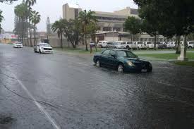
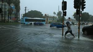
In Newcastle two people were rescued from a car by fire crews in Tighes Hill, and dozens of roads were closed due to flooding, including Industrial Drive at Mayfield, and University Drive at Waratah, where two cars were briefly underwater.
Between 30 and 60 millimetres of rain fell on parts of the city in less than half an hour on Tuesday afternoon, and 2200 homes lost power in Mayfield and Waratah.
In Wallsend, where the flash flooding was at its worst, Newcastle City Council send out evacuation alerts to residents warning of imminent flash flooding.
A number of low-lying streets in that suburb, including Nelson Street, were closed.
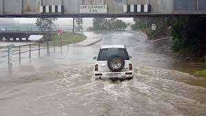
Cars were submerged on Maryland Drive, cricket grounds and skate parks inundated, and drains were transformed into rushing torrents of water.
State Emergency Services spokesman Phil Campbell said on Tuesday night that the majority of call outs had been for minor issues leak leaking roofs.
However, the Bureau of Meteorology flagged falls of as much as 200 millimetres of rain in some localised areas, as well as the potential for an east coast low pressure system to form off the coast, meaning conditions could worsen in the early hours of Wednesday.
Further north, heavy rain fell for most of the day in parts of the Myall Lakes and at Buladelah, where the main road had to be closed after more than 200 millimetres of rain fell in a 24 hour period.
Anthony Dorney lives on Markwell Road just north of Bulahdelah. He was up at 4am on Tuesday moving their cattle and horses to higher ground.
“I was wading through water about waist deep at 4am to get to them,” he said. “The paddocks they were in are under water now.”
A number of severe weather warnings and flood alerts remained in place overnight, with moderate flooding expected in the Hunter River at Bulga, and minor flooding of the Williams River at Dungog.
Two campers had to be rescued in the Myall Lakes, and five people clambered out of a car after it became stuck in about one metre of water at Pokolbin.
UPDATE, 7.30pm: THE State Emergency Service is responding to more than 200 calls for assistance across the lower Hunter on Tuesday night.
There were reports of flash flooding at a number of locations across Newcastle, with a number of roads inundated.
The majority of calls for assistance so far were in the lower Hunter in Newcastle and Maitland, the majority for minor roof leaks.
The Bureau of Meterology said that an average of 60 millimetres of rain has fallen in the past 24 hours to 6pm on Tuesday, with more forecast rain expected to cause minor flooding at Dungog and Mill Dam Falls later on Tuesday.
The Bureau said it was not possible to predict the flood peak because of uncertainty over how much more rain will fall.
However Dungog is expected to exceed the minor flood level of 4.9 metres at about 11pm on Tuesday, and Mill Dam Falls is expected to exceed the minor flood level of 6.1 metres at about 9am on Wednesday.
Phil Campbell from the State Emergency Services said the conditions were “no-where near” the April storms that swept through the Hunter, but predicted isolated rain falls of about 200 millimetres in some localised areas “could cause some issues”.
He said specialist crews had been placed at some areas including Dungog, and extra volunteers had been called in from Sydney.
While the majority of calls for assistance were for minor issues, there have been some rescues required.
Two campers were rescued by the State Emergency Services from a site at Myall Lakes, while at Tighes Hill firefighters reportedly rescued two people from a car caught in floodwater.
UPDATE, 6pm: TORRENTIAL rain has soaked parts of Newcastle on Tuesday afternoon, with some areas receiving between 30 and 60 millimetres in less than an hour.
There are currently flood warnings in place for Bulahdelah – where the main street is closed – and parts of the Hunter River near Bulga, while the Bureau of Meterology has also issued a flood watch for large swathes of the Hunter including Lake Macquarie and the Newcastle CBD.
Humid easterly winds are feeding into a trough on the NSW coast, generating widespread rain.
A small low pressure centre may form within the trough, most likely off the Hunter or Mid North Coast.
Widespread rain totals of 30 to 60 mm are likely during this time, and isolated falls of 200 mm are possible.
About 194 millimetres of rain fell on Bulahdelah between 9am on Monday and 9am on Tuesday.
Another 69 millimetres fell between 9am and 5pm.
Upper Chichester near Barrington Tops received 155 millimetres in that time, and Bungwahl copped 135 millimetres.
Closer to town the northern parts of Newcastle were the worst affected – with Wallsend among the worst, receiving 57 millimetres between 9am and 5pm.
The Bureau issued a flood warning for the Hunter River after as much as 105 millimetres of rain fell in the Wollombi Brook catchment area in the 24 hours to 4pm on Tuesday.
That’s expected to cause moderate flood levels of 3.7 metres in Bulga at about 8pm.
Further rain is likely, potential leading to high flood water levels.
The Bureau says that Singleton, Maitland and Raymond Terrace are likely to stay below the minor flood level.
source:theherald.com.au